Project duration
1 May 2017 – 30 April 2019
Stakeholders
Execution
- National University of Singapore (NUS)
- Ordnance Survey International (OSI)
Funding & programme coordinators
- National Research Foundation Singapore (NRF)
- Singapore Government Technology Agency (GovTech)
Collaborators
- Housing and Development Board (HDB)
Objective
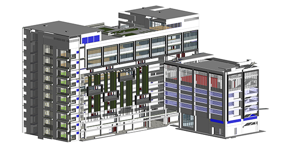
The primary project objective is the development of a methodology and algorithms to automate the mapping and conversion of IFC–BIM models into CityGML building models while ensuring a complete and near–lossless mapping. The mapping will capture both geometric and semantic information as available in the IFC–BIM models, in order to create semantically enriched 3D city models and to extend these city models to include exterior as well as interior structures such as corridors, rooms, internal doors, and stairs.
While automation has been demonstrated before, mainly for exterior building shells in LoD1 and LoD2, the focus of this proposal is on achieving a complete and near–lossless mapping for both exterior and interior structures in LoD4. A formal framework for strict (semantic and geometric) conversion will be developed, and additional (standard) specifications will be identified and defined, in order to improve the degree of automation and completeness of the mapping process. The development of the formal framework and the identification of these (standard) specifications are secondary project objectives.
The success of this project will be demonstrated using IFC–BIM models made available by HDB, as well as by major BIM software vendors. The development of the methodology and algorithms do not target the conversion of native BIM models as used by specific BIM software applications but, instead, BIM models in the IFC data format for openBIM. Considering that IFC is merely a data format and not a model specification, the project objective is to address a wide variety of IFC–BIM models as resulting from major BIM software applications and reflecting on how buildings and their indoor structures are modelled by different BIM users and practices.
Finally, the project not only aims to develop a methodology, algorithms, and conversion routines, but also, to support practical application if the resulting routines through training, the exploration of an operational service, resulting in a roadmap of necessary steps to scale and operationalise the methodology, and the exploration of commercialisation opportunities with major BIM software vendors.
Team
Principal Investigators
- Rudi Stouffs (PI, NUS Dept. of Architecture)
- Patrick Janssen (co-PI, NUS Dept. of Architecture)
Research fellows
- Helga Tauscher (NUS)
- Filip Biljecki (NUS)
- Salman Khalili Araghi (NUS)
- James Crawford (OSI)
Research assistants
- Amol Konde
- Kamel Adouane
- Joie Lim
Project structure and output
The project is divided into 3 sections, each focusing on one aspect relevant to the conversion process.
Native BIM to IFC

Based on studies regarding some possible use cases and desired output CityGML files, certain standards and workflows are required in the production and processing of these BIM files. This section is focused on the identification of issues found in typical examples of BIM files received that may need to be addressed as well as how the files may be processed to obtain more targeted IFC files for the conversion process downstream.
IFC to CityGML

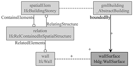
As the project aims to deliver a method of conversion that is flexible enough to adapt to changes in both the IFC and CityGML schemas, this section of the project which focuses on IFC to CityGML conversion is divided into two parts. The first is the development of rulesets that express the relationships between IFC and CityGML classes in a Triple Graph Grammar approach, allowing customisable rules for different use cases and possibly even CityGML to IFC conversion. The second is the implementation of a conversion engine which can use any of the defined rulesets to generate a CityGML file from IFC.
Publications
- Stouffs R, Tauscher H, Biljecki F (2018): Achieving Complete and Near-Lossless Conversion from IFC to CityGML. ISPRS International Journal of Geo-Information, 7(9): 355. ► doi
- Stouffs R (2018): A Triple Graph Grammar Approach to Mapping IFC Models into CityGML Building Models. Learning, Adapting and Prototyping - Proceedings of the 23rd CAADRIA Conference (CAADRIA 2018), volume 2, Tsinghua University, Beijing, China, 17-19 May 2018, pp. 41-50. ► pdf
- Tauscher H, Stouffs R (2018): An IFC-to-CityGML Triple Graph Grammar. Computing for a better tomorrow - Proceedings of the 36th eCAADe Conference (eCAADe 2018), volume 1, Lodz University of Technology, Lodz, Poland, 19-21 September 2018, pp. 517-524. ► pdf
- Tauscher H, Crawford J (2018): Graph Representations for Querying, Examination, and Analysis of IFC Data. eWork and eBusiness in Architecture, Engineering and Construction. Proceedings of the 12th European Conference on Product and Process Modelling (ECPPM), Copenhagen, Denmark, 12-14 September 2018, pp. 421-428. ► doi ► pdf
- Tauscher H, Stouffs R (2019): Extracting different spatio-semantic structures from IFC using a triple graph grammar. Intelligent and informed: 24thAnnual Conference of the Association for Computer-Aided Architectural Design Research in Asia (CAADRIA 2019), volume 1, Wellington, New Zealand, pp. 605-614. ► pdf
- Tauscher H (2019): Creating and maintaining IFC-CityGML conversion rules. ISPRS Ann. Photogramm. Remote Sens. Spatial Inf. Sci., IV-4/W8: 115–122. ► doi
- Lim J, Tauscher H, Biljecki F (2019): Graph transformation rules for IFC-to-CityGML attribute conversion. ISPRS Ann. Photogramm. Remote Sens. Spatial Inf. Sci., IV-4/W8: 83–90. ► doi
- Biljecki F, Tauscher H (2019): Quality of BIM–GIS conversion. ISPRS Ann. Photogramm. Remote Sens. Spatial Inf. Sci., IV-4/W8: 35–42. ► doi
- Tauscher H, Lim J, Stouffs R (2021): A Modular Graph Transformation Rule Set for IFC-to-CityGML Conversion. Transactions in GIS, 25: 261–290. ► doi
CityGML and ADEs

Many use cases may require additional information that cannot of stored in the CityGML format but are available in the Native BIM and IFC files. This section of the project focuses on the geospatial end of the project, e.g. development of an Application Domain Extension (ADE) extending the standard CityGML schema to allow such information to be retained in the conversion process.
Publications
- Biljecki F, Kumar K, Nagel C (2018). CityGML Application Domain Extension (ADE): overview of developments. Open Geospatial Data, Software and Standards, 3(1): 13. ► doi
- Konde A, Tauscher H, Biljecki F, Crawford J (2018): Floor plans in CityGML. ISPRS Ann. Photogramm. Remote Sens. Spatial Inf. Sci. IV-4/W6: 25-32 (3D GeoInfo 2018). ► doi
- Lim J, Janssen P, Biljecki F (2020): Visualising detailed CityGML and ADE at the building scale. ISPRS - International Archives of the Photogrammetry, Remote Sensing and Spatial Information Sciences, XLIV-4/W1-2020: 83-90. ► doi
- Biljecki F, Lim J, Crawford J, Moraru D, Tauscher H, Konde A, Adouane K, Lawrence S, Janssen P, Stouffs R (2021): Extending CityGML for IFC-sourced 3D city models. Automation in Construction, 121: 103440. ► doi
Other Publications
- Crawford J (2018): Enhancing Virtual Singapore with BIM Data. Geomatics World 26(5): 26-28. ► online
Awards
Acknowledgements
This material is based on research/work supported by the National Research Foundation under Virtual Singapore Award No. NRF2015VSG-AA3DCM001-008.